High Resolution Carbon Monitoring and Modeling: A CMS Phase 2 Study (2012-2015)
This CMS project wrapped up in 2015. However our work and partnerships with stakeholders across the state have continued as part of our continued prototype development and deployment of high resolution carbon monitoring and modeling over the mid-Atlantic states of Maryland, Delaware and Pennsylvania (TriState)
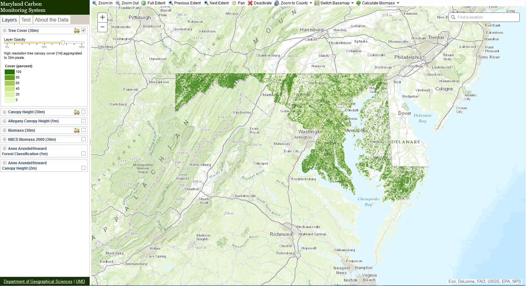
One goal of this project is to publish our data in a user-friendly format, for a wide public audience. Our data is available for direct download in formats compatible with ESRI and other commonly used GIS software packages. Clicking the below link will open a new tab containing this map. You can check on or off various layers, and select the measurement to tool to calculate the mean biomass, tree height, or canopy cover in an area. Several other map layers from related projects are also available. For more information about the layers, please view the data site.
This page provides archives of published base line biomass maps and tools from the project.
Ecometrica Mapping Platform
- Analyze high-resolution maps of aboveground biomass, carbon sequestration, landcover and forest structure.
- Query district protected areas of user-defined areas to view forest carbon data summaries/statistics.
- View and download detailed reports.
Link to Ecometrica Mapping Platform: Link

Interactive Map
One goal of this project is to publish our data in a user-friendly format, for a wide public audience. Our data is available for direct download in formats compatible with ESRI and other commonly used GIS software packages. Clicking the below link will open a new tab containing this map. You can check on or off various layers, and select the measurement to tool to calculate the mean biomass, tree height, or canopy cover in an area. Several other map layers from related projects are also available. For more information about the layers, please view the data site.
Link to Maryland Carbon Monitoring System: Web Map
ESRI On-line Map Services
The resulting maps of this project are available for download via the standard ESRI ArcServer interface. The Biomass maps and Canopy Cover maps are currently hosted via Maryland iMap, and can be accessed at their website as both Map Services and Image Services. Access to the Canopy Height and ED Model estimate maps will be made available soon.
Link: Biomass and Canopy Cover Maps
Research Objectives
- Improve our existing methodology for carbon stock estimation and uncertainty and assess its efficacy across an expanded range of environmental and forest conditions.
- Provide high-resolution estimates of carbon stocks and their uncertainties for the entire state of Maryland representing Eastern U.S. forest types.
- Initialize and run a prognostic ecosystem model to estimate carbon stocks and fluxes, and to estimate carbon sequestration potential.
- Provide detailed validation of national biomass maps using FIA data and high-resolution biomass maps.
- Demonstrate new data acquisition technology, micropulse single photon lidar (SPL), for low-cost, rapid large-area carbon assessments.
Project Deliverables
- Tiled and mosaicked canopy height and forest/non-forest maps at 2 m and 30 m resolution for Maryland
- Aboveground Biomass (AGBM) maps at 30 m resolution with associated uncertainty maps for Maryland Counties and Addison County
- ED-model based carbon and carbon-flux maps at 90 m resolution for Maryland
- ED-model maps of carbon sequestration potential for Maryland under various climate change scenarios
- SPL canopy height map for Allegheny County and derived biomass
- Demonstration of a web-based data visualization and query system
- Assessment of main sources of error and proposed strategies for reducing errors in future deployment of an operational CMS
Project Related Links
Data Availability
- Statewide biomass, canopy cover and height (30m) and individual county (1m, 1.2m, 2m) high resolution tree canopy can also be viewed on http://geodata.md.gov/imap/biota
- Dubayah, R.O., A. Swatantran, W. Huang, L. Duncanson, K. Johnson, H. Tang, J.O. Dunne, and G.C. Hurtt. 2016. CMS: LiDAR-derived Aboveground Biomass, Canopy Height and Cover for Maryland, 2011. ORNL DAAC, Oak Ridge, Tennessee, USA. DOI: 10.3334/ORNLDAAC/1320
- First Phase 2 County Research Datasets: Cook, B., A. Swatantran, L. Duncanson, A. Armstrong, N. Pinto, R. Nelson. 2014. CMS: LiDAR-derived Estimates of Aboveground Biomass at Four Forested Sites, USA. ORNL DAAC, Oak Ridge, Tennessee, USA. DOI: 10.3334/ORNLDAAC/1257
- To learn more about methodology to create high resolution cover see: O'Neil-Dunne J, MacFaden S, Royar A, Reis M., Dubayah R. and Swatantran A. (2014) An Object-Based Approach to Statewide Land Cover Mapping. ASPRS. Louisville, KY http://www.asprs.org/a/publications/proceedings/Louisville2014/ONeilDunne.pdf
Information on Forest Biomass Estimation Methods
- Ecosystem Demography Model (ED Model): http://gel.umd.edu/ed.php
- CMS LiDAR-derived Random Forest (RF) Above Ground Biomass, Canopy Height and Cover for Maryland: http://daac.ornl.gov/CMS/guides/CMS_Maryland_AGB_Canopy.html
Links to specific projects on the CMS website
- High Resolution Carbon Monitoring and Modeling: A CMS Phase 2 Study (2012-2015) - Dubayah-03 http://carbon.nasa.gov/cgi-bin/cms/inv_pgp.pl?pgid=650
- High-Resolution Carbon Monitoring and Modeling: Continuing Prototype Development and Deployment (active) - Hurtt0-03 http://carbon.nasa.gov/cgi-bin/cms/inv_pgp.pl?pgid=3136